
M. Reza Najafi
Contact
Department of Civil and Environmental Engineering
Spencer Engineering Building,
Room 3079
Western University
Tel: 519-661-2111 ext. 86428
Fax: 519-661-3779
mnajafi7@uwo.ca
Research
The Hydroclimate Extremes and Climate Change Lab works at the intersection of water resources engineering, climate change and hydroclimatic extremes. We study how floods, droughts and their combinations are changing, and what those changes mean for the infrastructure and communities exposed to them, in partnership with Environment and Climate Change Canada, the National Research Council, conservation authorities and municipalities across the country.
Research Themes
Nonstationary Compound Hydroclimatic Extremes under Climate Change
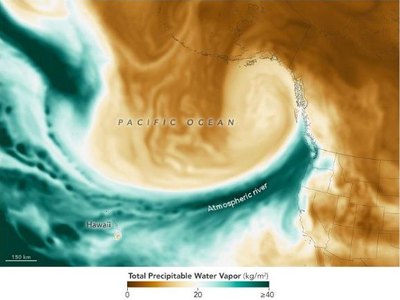 Atmospheric river, 4 December 2023. NASA Earth Observatory. Atmospheric river, 4 December 2023. NASA Earth Observatory. |
Floods rarely arrive from one direction. We characterize events in which storm surge, waves, river discharge and heavy rainfall coincide, across Canada’s Pacific, Atlantic, Arctic and Great Lakes coasts, and quantify how their joint probability shifts as the climate warms. Treating each driver separately, as conventional univariate methods do, systematically understates the hazard. Recent work identifies the storm mechanisms that drive dependence between the drivers: extratropical cyclones, atmospheric rivers and post-tropical systems. Methodologically the work combines multivariate frequency analysis and copula based dependence models with hydrodynamic simulation of coincident drivers, so that a design condition reflects the combination rather than the worst single driver. The results feed directly into national coastal flood guidance. Selected papers
|
Integrated and Data-Driven Flood Risk Assessment
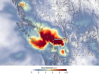 Rainfall, British Columbia, 14 November 2021. NASA Earth Observatory. Rainfall, British Columbia, 14 November 2021. NASA Earth Observatory. |
Coupling process based hydrologic and hydraulic models with statistical and machine learning methods to map flood hazard, exposure and vulnerability at scales municipalities can act on. This includes regional flood frequency frameworks for ungauged basins, revised design rainfall and probable maximum precipitation for dams and levees, evaluation and bias correction of satellite and radar precipitation products, and building scale exposure attributes extracted automatically from LiDAR, orthophotos and street imagery. The aim throughout is decision ready output: hazard maps that carry their own uncertainty, exposure inventories that can be assembled for a whole municipality without a field survey, and design values an engineer can defend to a regulator. Selected papers
|
Dynamics of Lagged Hydroclimatic Transitions under Climate Change
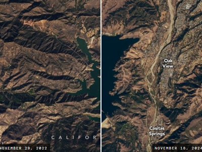 Lake Casitas, 2022 and 2024. NASA Earth Observatory. Lake Casitas, 2022 and 2024. NASA Earth Observatory. |
Extremes increasingly arrive in sequence rather than singly: a drought followed closely by a flood, a warm and wet spell followed by a hot and dry one. We produced the first systematic assessment of these lagged transitions across Canada, and project how their frequency, severity and spatial footprint change under warming, including rain on snow floods and snow drought. Sequenced extremes matter because the stores that absorb them, soil moisture, snowpack and reservoir storage, do not reset between events. We quantify how quickly a basin flips from deficit to surplus, and which regions of Canada are becoming more prone to that swing. Selected papers
|
Detection, Attribution and Internal Climate Variability
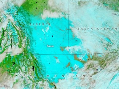 Early snow, Canadian prairies, 2019. NASA Earth Observatory. Early snow, Canadian prairies, 2019. NASA Earth Observatory. |
Separating the human fingerprint from natural variability in observed snowpack, streamflow and temperature, using large single model ensembles and formal detection and attribution methods. This line of work established anthropogenic influence on the spring snowpack decline in British Columbia, on Northern Hemisphere snow cover extent, and on Arctic temperature change. Attribution matters practically as well as scientifically: if a trend is forced rather than an artefact of natural variability, it belongs in the design values that infrastructure is sized against, and in the non-stationary assumptions behind them. Selected papers
|
Multi-Hazard Risk and Infrastructure Resilience
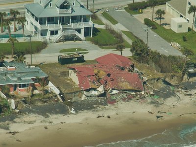 Coastal erosion, Hurricane Jeanne, 2004. USGS. Coastal erosion, Hurricane Jeanne, 2004. USGS. |
Water, power and transport systems fail together. Using dynamic Bayesian networks and system of systems analysis we quantify how hazards cascade across interdependent infrastructure, how service is restored, and where intervention buys the most resilience. This work is carried out through the Centre for Multihazard Risk and Resilience, which brings together more than twenty faculty members across three faculties at Western. The output is a ranked set of interventions rather than a single risk number, since restoring one component early can shorten outages across an entire network. Selected papers
|
Guidance and Partnerships
Findings from this programme feed directly into national guidance: Lead Author of the Floods chapter and Contributing Author on the Extremes chapter of Canada’s National Climate Change Assessment; Lead Author of the CSA W224 Implementation Guide for Coastal Flood Risk Assessment; technical guidance on design floods for dams and levees with the National Research Council; stormwater and intensity, duration, frequency work with the City of Toronto, York Region and the City of Caledon.
Models and Data
Hydrology and hydrodynamics: SFINCS, LISFLOOD-FP, TELEMAC-2D, PCSWMM, Raven, WRF-Hydro, HEC-HMS and HEC-RAS.
Climate and reanalysis: CMIP6, CanLEAD, d4PDF and other large ensembles, ERA5, CanRCM4.
Observations and remote sensing: station and radar networks of Environment and Climate Change Canada, National Research Council coastal data, GTSM, GPM IMERG, MRMS, Sentinel-1, RADARSAT and LiDAR.
Grants and Projects
Currently Held
- NSERC Discovery Grant, Nonstationary Compound Hydroclimatic Extremes in a Changing Climate: Implications for Infrastructure Resilience (PI), 2024-2029.
- Government of Ontario, Early Researcher Award, An Integrated Framework to Characterize the Concurrent and Sequential Occurrence of Multiple Flood Hazards across the Great Lakes Basin under Climate Change (PI), 2024-2029.
- Environment and Climate Change Canada, Integrated Framework for Assessing Compound Coastal and Inland Flooding under Climate Change Across Canada (PI), 2024-2027.
- New Frontiers in Research Fund (International), Community and Infrastructure Resilience to Climate-geological Long-term Effects (CIRCLE) (CoPI), 2024-2027.
- SSHRC Insight Grant, Canadian Disaster Rapid Response Research (3R) Enhancement: Initiating a Researcher Platform and Coordination Network (Can-3R) (CoPI), 2023-2026.
- NSERC / Mitacs Alliance-Accelerate, The Northern Hail Project: Uncovering the Meteorology, Climatology, and Impacts of Hailstorms in Canada (CoPI), 2022-2026.
- Digital Research Alliance of Canada, High-Resolution Climate and Hydrodynamic Modelling for Compound Flood Risk Assessment Across Canada, Resource Allocation Competition (PI), 2025-2026.
- National Research Council Canada, Projected Climatic Data for Dam Design and Management (PI), 2023-2025.
- National Research Council Canada, Guidelines for Estimating Design Floods to Support Climate-Resilience of Dams and Levees (PI), 2021-2025.
- Western University, Interdisciplinary Development Initiatives Program, Approaches towards Sustainable Water Resources Management for Remote Communities (CoPI), 2023-2025.
Selected Past Projects
- Lea Consulting Ltd., Development of a Flood Risk Assessment Model for Infrastructure in York Region (PI), 2023-2024. Recipient of the Ontario Engineering Project Award, Sustainable Development Impact Category, 2025.
- Environment and Climate Change Canada, Characterizing Compound Flooding in Canadian Coastal Areas: Historical and Future Conditions (PI), 2023-2024.
- Environment and Climate Change Canada, Statistical Downscaling of Hydro-climatic Variables for the Great Lakes Region (PI), 2023.
- City of Toronto, CivicLabTO, Review of Best Practices: Stormwater Management Modelling and Climate Change (PI), 2022-2023.
- NSERC Alliance Grant, An Integrated Risk Assessment Framework for Compound Flooding in Canadian Urban Environments (PI), 2020-2023.
- Institute for Catastrophic Loss Reduction, Assessing the Impact of Cloud Seeding on Hail Damage in Alberta (PI), 2020-2023.
- Canadian Queen Elizabeth II Diamond Jubilee Scholarships (QES), Scholars Network for Building Disaster Resilient Communities (CoPI), 2020-2024.
- NSERC Discovery Grant, Improved Characterization of Hydroclimatic Extremes through the Development of a Comprehensive Nonstationary Modelling Framework (PI), 2017-2022.
Sponsors
 |
 |
 |
 |
 |
 |
 |
 |
 |





