
Hydrogeophysical Characterization and Monitoring
Background
The ability to observe the fabric of the subsurface environment and processes that occur within it remains a significant challenge. The complex and multiscale interactions between physical, biological, and geochemical processes are difficult to observe and thus hinder our ability to understand, predict, and ultimately manage shallow systems in a sustainable manner. Traditional sampling of the subsurface has been widely based on invasive drilling approaches, through the recovery of samples (e.g., cores) and installation of fluid sampling apparatus. However, these approaches are constrained by their cost, labor and density of measurements. Geophysical methods have emerged as valuable tools for non-invasive and continuous imaging of subsurface processes, with significant advancements ongoing to make their application more and more popular.
Geophysical characterization of ‘hidden’ subsurface features and processes (source: Binley et al., 2015)
Program Objectives
The overall objective of this program is to assess and develop geophysical methods, including DC resistivity, induced polarization (IP) and electromagnetics (EM), to be deployed as common tools as part of characterization and monitoring strategies for various geoenvironmental investigations. Specific project objectives include:
- Apply geophysical methods to characterize the composition of mining waste within waste rock and tailings ponds;
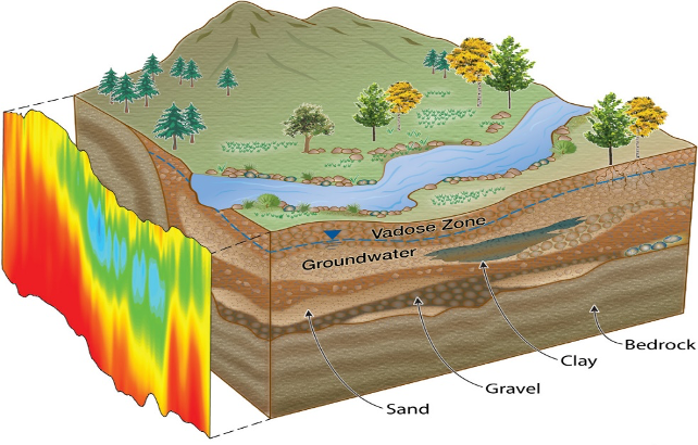
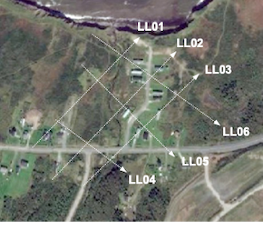
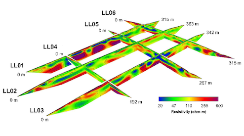
- Evaluate the effectiveness of geophysical methods to characterize and monitor the interface zone between groundwater and surface water; and
- Develop a non-invasive electrical method for assessing the integrity of various engineered liner systems used at waste management facilities.
Research Methods
Field Investigations
Geophysical surveys are being conducted at a number of field sites of environmental interest, including: (i) mine waste rock piles generating acid mine drainage, (ii) rural streams receiving nutrient loading from adjacent agricultural land, and (iii) stormwater management systems such as bioretention systems. Standalone geophysical surveys are being used to characterize subsurface features of interest (e.g., geology, mineralogy) while repeat surveys allow time-lapse monitoring of key subsurface processes, such as moisture content changes and water quality evolution.
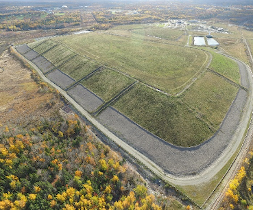
Characterization of the internal composition of a mine waste rock pile with combined DC-IP

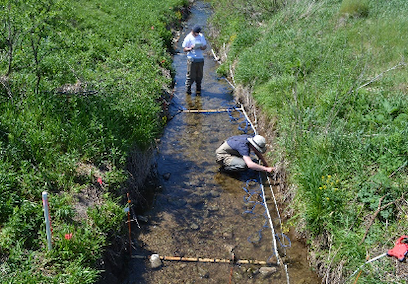
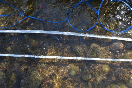
Electrical resistivity and chargeability measurements taken within an agricultural stream to assess streambed heterogeneity and its influence on groundwater-stream interactions
Electrical detection of defects in geomembrane-lined cover systems at waste rock piles
Click here for more project photos
Program Output
Journal Papers (2018 - 2020)
Power, C., Tsourlos, P., Ramasamy, M., Nivorlis, A., Mkandawire, M. (2018) Combined DC resistivity and induced polarization (DC-IP) for mapping the internal compositions of a mine waste rock pile in Nova Scotia, Canada. Journal of Applied Geophysics, 150, 40-51. doi: 10.1016/j.jappgeo.2018.01.009
Angelis, D., Tsourlos, P., Tsokas, G., Vargemezis, G., Zacharopulou, G., Power, C. (2018) Combined application of GPR and ERT for assessment of a wall structure at the Heptapyrgion Fortress (Thessaloniki, Greece). Journal of Applied Geophysics, 152, 208-220.
Selected Conference Presentations
Robinson, K., Vissers, M., Power, C., Roy, J.W., Robinson, C.E. (2020). Role of groundwater-surface water interactions in delivering phosphorus to agriculture streams. 55th Central Canadian Symposium on Water Quality Research, Canadian Association on Water Quality (CAWQ), February 20, 2020, Toronto, Ontario, Canada.
Almpanis, A., Power, C. (2019) Integrating multiple geoelectrical techniques with hydrogeochemical data to characterize a coal mine waste rock pile. American Geophysical Union (AGU) Fall Meeting 2019, San Francisco, United States.
Power, C., Tsourlos, P. (2019) Characterization of a mine waste rock pile with the DC resistivity and induced polarization (DC-IP) method. Near Surface Geoscience 2019 – 25th European Meeting of Environmental and Engineering Geophysics, The Hague, Netherlands.
Tsourlos, P., Vargemezis, G., Fikos, I., Power, C. (2017) Geoelectrical monitoring for locating leaking points at landfills. Near Surface Geoscience 2017 – 23rd European Meeting of Environmental and Engineering Geophysics, Workshop (Geophysics for Mapping and Monitoring of Contaminated Ground and Buried Waste), Malmo, Sweden. (Invited)
Project Team
Project Leaders:
with
Project Members:
Ethan Kamps, BEng (completed 2020)
Ryan Murphy, BEng (completed 2018)
Supporting Organizations: