
Range Sensing and Geometric Modeling
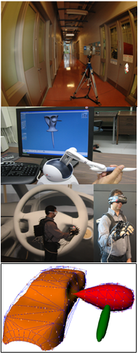
Range scanners have become the primary tool for capturing arbitrary surface geometry of pre-existing objects or large civil structures and spaces. However, the digitization process generates an immense cloud of 3D coordinate data that exhibit significant measurement errors due to scanner noise, partial or missing information, and data density variations.
Researchers at UWO and NRC-IRC are developing new methods to reduce scanning errors and improve spatial accuracy by exploiting redundant data in multiple partial scans. The captured data is used to create 3D virtual reality models of buildings and structures.
Another collaborative project involves the development of a computational framework for manipulating deformable free-form objects in virtual environments. The core algorithms for haptic rendering, collision detection and physics-based modeling assume that all deformable objects can be represented as parametric B-spline surfaces.
Collaborating Researcher: Dr. Roberto Canas (NRC-IRC, London)